|
Issued: 0937 Saturday 21 October 2017
Duty forecaster: John Ejdowski
Dry from mid week
The start of this upcoming week will be unsettled as remnants of Storm clear from the North Sea. We will see a cell of high pressure taking over from around mid week and as this builds north, all parts of the country are expected to turn dry. Temperatures will be mild to quite mild overall.
For the weather for the next few days click here
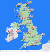
Tuesday 24/10/17
Milder conditions are expected today with temperatures above normal. We may see a band of moderate to heavy rain slow moving across southern Scotland, Northern Ireland and northern England. Dry to the north and south. Further showers to come across Scotland in the night with most areas dry. Expect highs of 14 to 19C.
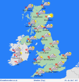
 Wednesday 25/10/17 Wednesday 25/10/17
An area of rain through central areas tends to narrow and become lighter through the afternoon. To the north and the south it appears fair and dry apart from showers for north west Scotland. It continues mild for most. That rain pushes north overnight. Expect highs of 13 to 19C.
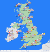
 Thursday 26/10/17 Thursday 26/10/17
Thursday is likely to stay mild. Rain across Scotland tends to clear by the afternoon. Most places look dry with lots of sunshine after fog patches clear central and southern England. Look for highs of 13 to 19C.
 Friday 27/10/17 Friday 27/10/17
Very mild and with high pressure in charge, expect a fine, dry day across much of Britain. Good spells of sunshine to come but there may be a good deal of low cloud and fog around in the morning. Expect highs of 14 to 19C.
Saturday 28/10/17
Another mild, dry day to come on Saturday. Best of the sunshine may be in the north and the west as a north east flow may bring in occasional cloud to eastern areas. Expect highs of 14 to 18C.
Sunday 29/10/17
With high pressure in charge, it's going to be another dry day across the United Kingdom. After a chilly start, mist and fog patches clear with most places having some decent spells of sunshine. Look for highs of 14 to 19C.
|
