|
Often unsettled as low pressure dominates and still rather chilly as well. Continued signs of a possible cold Easter too
For the weather for the next few days click here
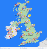
Sunday 25/3/18
A chilly start to Sunday across much of the British Isles with a slight frost and some mist of fog patches too. Through the day and a mixture of sunshine and showers will develop, most of the showers across N England, Scotland and Ireland where some local downpours are possible. The showers will be more scattered across central and southern areas of England and Wales where quite a lot of dry and bright weather is predicted. Winds mainly light for most areas. High 6C to 10C.
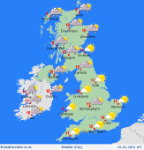
 Monday 26/3/18 Monday 26/3/18
Another chilly start is possible into early next week with a slight frost again and some mist or fog patches too. Showery conditions are forecast to continue at the moment, perhaps especially across more northern and west areas and across Ireland in particular some longer spells of rain may arrive, from the west, later in the day. Showers more scattered across southern and eastern areas of England so drier here with some bright or sunny spells. Winds mainly light still, but becoming moderate W or SW'ly further north and west. Near or slightly below average temperatures. Highs 6C to 11C.
 Tuesday 27/3/18 Tuesday 27/3/18
Low pressure is set to develop and arrive from the west through the course of the day bringing an increased risk of rain or showers, initially across western areas, but then spreading eastwards through the day. Some temporary drier and brighter weather may still be possible across southern and eastern areas of England, but even here some rain or showers are possible later in the day. Perhaps becoming windy in the west with a fresh or strong S or SW'ly wind. A milder day, highs 7C to 12C.
 Wednesday 28/3/18 Wednesday 28/3/18
Unsettled conditions are forecast to continue through into next Wednesday as low pressure continues to dominate the weather. There are uncertainties over the details, but further rain or showers are possible at times, through the day, perhaps with some locally heavy showers in the north and east and perhaps with some wintry precipitation returning to northern hills. Turning colder in the north, still milder in the south. Wind, especially in the north and west. Highs 3C to 6C in the north, 5C to 10C in the south.
Thursday 29/3/18
Low pressure is expected to be situated over the British Isles through the day maintaining a risk of sunshine and showers and perhaps with some longer spells of rain in places. A continued progression towards colder weather is possible across the northern half of the British Isles in particular with sleet and snow showers certainly possible across higher ground in the north. Overnight frost and icy patches possible, winds fairly light through central areas, but windy in the far north and south. Highs 2C to 8C, lowest in the north.
Friday 30/3/18
Into Good Friday and a progression towards colder and more wintry conditions does seem the most likely evolution at the moment as winds become N'ly or perhaps even NE'ly moderate or locally fresh. Some rain or sleet is possible across southern areas of England and Wales, perhaps clearing through the day and then the rest of the British Isles having a mixture of sunshine and wintry showers, but with snow and hail showers to lower levels in the north. Overnight frost and icy patches fairly widespread. Highs 2C to 5C.
|
