|
Issued: 0940 Saturday 2 December 2017
Duty forecaster: John Ejdowski
Strong gales, freezing wind chill developing
The start of this week sees the jet stream traversing across the north as it becomes milder. As a deep low develops and runs across Britain on Thursday, the jet turns to the north and looks to sweep Arctic air southward across Britain changing rain to snow. The remainder of the week appears cold and wintry with a bitter wind chill and a risk of snow or snow showers. Temperatures fall from just above normal to well below normal. Strong gales may affect the country.
For the weather for the next few days click here
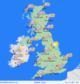
Tuesday 05/12/17
It looks a bit colder in places today. Increasingly windy across northern Britain. Rain reaches Northern Ireland and western Scotland later in the day. Dry for the rest of Britain with sunny spells but turning cloudier in the west. A windy night with rain across Scotland and Northern Ireland. Expect highs of 7 to 9C.
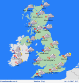
 Wednesday 06/12/17 Wednesday 06/12/17
Expect a milder, windy day with plenty of cloud. Showers and some light rain affects the west in the morning. Rain extends into most areas in the afternoon. Very wet with heavy rain overnight across England and Wales which will be accompanied but strong south westerly winds. It turns colder with rain changing to snow. Expect highs of 9 to 11C.
 Thursday 07/12/17 Thursday 07/12/17
It looks to turn much colder with a risk of very strong north west winds touching gale to severe gale force over the hills. Heavy rain changes to snow across England and Wales as it clears away. A very cold and windy afternoon with a risk of snow showers across western and eastern areas down to low levels. It continues very windy overnight with a risk of snow and snow showers for many. Confidence is low on the detail at present. Look for highs of 2 to 6C.
 Friday 08/12/17 Friday 08/12/17
It stays cold and very windy with possible gales across northern Britain. There remains the risk of snow and wintry showers with local accumulations. Feeling bitter with a significant wind chill and temperatures look well below normal. Snow showers to affect west and eastern areas with icy patches inland. Expect highs of 1 to 3C.
Saturday 09/12/17
Not quite as bitter but still cold with temperatures below normal and we keep a significant wind chill in strong north west winds. Lots of dry sunny weather inland while eastern and western areas have the risk of occasional snow showers to low levels. Expect highs of 3 to 5C.
Sunday 10/12/17
Again confidence in the detail for Sunday is rather low but at present it may stay quite wintry with a cold, windy day bringing snow showers first to western and eastern coasts but there is also a risk of snow into central areas with accumulations possible. Look for highs of 3 to 5C but feeling below freezing in the strong winds.
|
