|
Issued: 1000hrs Thursday 7th December 2017
Duty forecaster: Garry Nicholson
Messy mix of rain and snow
It will be cold for all this weekend. Saturday will bring plenty of crisp winter sunshine and a few snow showers locally. Sunday has a risk of widespread disruptive snowfall for central and northern England and Wales as a weather system moves in from the Atlantic. Southern Britain is more likely to see rain. The week ahead will stay generally cold, with frost and ice, plus additional snow at times.
For the weather for the next few days click here
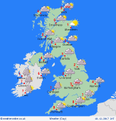 Sunday 10/12/17 Sunday 10/12/17
An area of low pressure moves across central Britain & Ireland, bringing a complex mix of rain and snow. Areas from the Midlands northwards have a high likelihood of heavy snow for many hours. A tricky mix of rain and snow for central England - snow mainly high ground. Southern regions should just see rain. Largely dry and bright for Scotland, although risk of local snow showers. Temperatures ranging from 0 or -1C north, up to 6 or 7C in southern England.
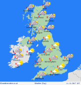 Monday 11/12/17 Monday 11/12/17
A cold day for all. Low pressure pulls away south into Europe, drawing cold air back across all of the British Isles from the north. Areas of residual snow possible, locally giving some disruptive falls. Snow showers most frequent around coasts in the west & north. Widespread ice, and previous lying snow will likely result in transport disruption. Staying close to freezing for most. Locally 5C around coasts in the south.
 Tuesday 12/12/17 Tuesday 12/12/17
Staying cold with overnight temperatures well below freezing for some. A general north-westerly pattern influences the country. A bright day, with crisp winter sunshine. Wintry showers around coasts exposed to the breeze, resulting in frequent snow over the hills in Wales & northern Scotland. Central inland regions should stay mainly dry. Temperatures 0 to 3C for most, locally 5 or 6C near coasts in the south-west.
Wednesday 13/12/17
The next complex area of low pressure moves in from the Atlantic, bringing another messy day of rain and snow. A chance that milder air advances further across the country, meaning more areas will see rain and a thaw of previous snow cover. However, rain may be preceded by snow, and in northern regions it may stay as snow for many hours. Blustery winds. Highs 2 to 7C.
Thursday 14/12/17
Most likely on the chilly side, with north-westerly winds. Areas of wintry showers, widely of snow inland and over the hills in northern regions. Some bright or sunny spells. Highs 1 to 6C, mildest near coasts in south-west.
Friday 15/12/17
Staying cool or cold. Further wintry showers possible. Frosty overnight. Some sunshine by day. Highs 1 to 7C.
|
