|
Issued: 0900hrs Monday 4th December 2017
Duty forecaster: Garry Nicholson
A cold weekend ahead
In the short term, mild air resides across the British Isles, but this will quickly give way to much colder conditions by the end of the week. An active weather system passes through on Thursday, which then ushers in a surge of Arctic winds. Clusters of snow and hail showers may give some locally disruptive snowfalls. Temperatures will struggle to climb above freezing for a few days.
For the weather for the next few days click here
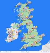 Thursday 07/12/17 Thursday 07/12/17
An active area of low pressure moving across Britain & Ireland brings a generally unsettled day. A period of heavy rain passes eastwards, accompanied by sudden bursts with squally winds gusting gale force in exposed places. Clusters of showers then spread from the north, turning increasingly wintry as cold air arrives quickly. Starting at 12 or 13C in the south & east, but dropping sharply to 5C or below from the north-west.
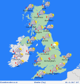 Friday 08/12/17 Friday 08/12/17
Strong northerly winds bring a renewed wintry feel to things by the end of this week. Areas of heavy snow and hail showers draped around coasts in the west, east and north, at times giving frequent falls. In northern Scotland, heavy snow may last for many hours, resulting in blizzard conditions. Central inland parts of Britain should escaped mainly dry with sunshine. Local bands of snow showers are possible. Cold at just 1 to 5C.
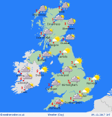 Saturday 09/12/17 Saturday 09/12/17
Northerly winds are likely to continue, bringing frequent snow to eastern coastal districts, plus northern Scotland. A few bands of showers may also affect some Irish sea coasts, perhaps running into north Wales. Pressure is likely to build toward the north-west. Feeling bitterly cold in the wind. Frosty where sheltered. Highs 1 to 4C.
Sunday 10/12/17
Confidence becomes low: A cold and frosty situation is likely. Further snow showers are possible around North Sea coasts. Low pressure and fronts trying to move in from the Atlantic bring a risk of snow elsewhere, turning to rain in the south-west. Just 0 to 3C for most.
Monday 11/12/17
Low confidence: Most likely remaining cold. A risk of snow showers for some, but also plenty of dry, bright and crisp wintry weather. Highs 0 to 3C.
Tuesday 12/12/17
A gradual transition to milder conditions may take place as winds turn west to northwesterly. Some rain arriving, which may be preceded by snow. Highs 1 to 7C.
|
