|
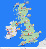 Tuesday Tuesday
High pressure located to the south of Britain maintains generally mild and dry conditions for many places. A brisk west to southwesterly breeze affects northern areas. Rain in north-west Scotland is likely to turn persistent. Patchy rain or drizzle around western coasts and hills elsewhere, plus extensive cloud. Brightest skies toward the east of the country. Some early fog in low-lying southern regions. Highs 7 to 10C.
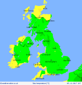 Tuesday night Tuesday night
A mild night in the north and west with a strong breeze continuing. Persistent and heavy rain for western Scotland. A little rain for western areas elsewhere. Rain also moves into Ireland from the west as fronts arrive. Otherwise staying dry. Mostly cloudy, but some breaks toward the east. Lowest temperatures 3 to 5C rural spots of central & eastern Britain, but nearer 6 to 9C for the north & west.
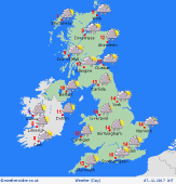
 Wednesday Wednesday
A strong southwesterly wind affects most areas as low pressure moves toward the British Isles from the Atlantic. Gales developing around western coasts. Fronts bring rain to the west and north-west, turning heavy over the hills, with some prolonged falls continuing into the night. Spots of rain in the wind elsewhere, but many places should stay dry all day. A mild day, highs widely 10 to 12C.
 Thursday Thursday
An active area of low pressure moving across Britain & Ireland brings a generally unsettled day. A period of heavy rain passes eastwards, accompanied by sudden bursts with squally winds gusting gale force in exposed places. Clusters of showers then spread from the north, turning increasingly wintry as cold air arrives quickly. Starting at 12 or 13C in the south & east, but dropping sharply to 5C or below from the north-west.
|
